
North America’s Geological History
January 24, 2015 5:00pm by Barry Ritholtz

This content, which contains security-related opinions and/or information, is provided for informational purposes only and should not be relied upon in any manner as professional advice, or an endorsement of any practices, products or services. There can be no guarantees or assurances that the views expressed here will be applicable for any particular facts or circumstances, and should not be relied upon in any manner. You should consult your own advisers as to legal, business, tax, and other related matters concerning any investment. The commentary in this “post” (including any related blog, podcasts, videos, and social media) reflects the personal opinions, viewpoints, and analyses of the Ritholtz Wealth Management employees providing such comments, and should not be regarded the views of Ritholtz Wealth Management LLC. or its respective affiliates or as a description of advisory services provided by Ritholtz Wealth Management or performance returns of any Ritholtz Wealth Management Investments client. References to any securities or digital assets, or performance data, are for illustrative purposes only and do not constitute an investment recommendation or offer to provide investment advisory services. Charts and graphs provided within are for informational purposes solely and should not be relied upon when making any investment decision. Past performance is not indicative of future results. The content speaks only as of the date indicated. Any projections, estimates, forecasts, targets, prospects, and/or opinions expressed in these materials are subject to change without notice and may differ or be contrary to opinions expressed by others. The Compound Media, Inc., an affiliate of Ritholtz Wealth Management, receives payment from various entities for advertisements in affiliated podcasts, blogs and emails. Inclusion of such advertisements does not constitute or imply endorsement, sponsorship or recommendation thereof, or any affiliation therewith, by the Content Creator or by Ritholtz Wealth Management or any of its employees. Investments in securities involve the risk of loss. For additional advertisement disclaimers see here: https://www.ritholtzwealth.com/advertising-disclaimers Please see disclosures here: https://ritholtzwealth.com/blog-disclosures/
What's been said:
Discussions found on the web:Posted Under
Previous Post
Forecasting is Marketing . . .
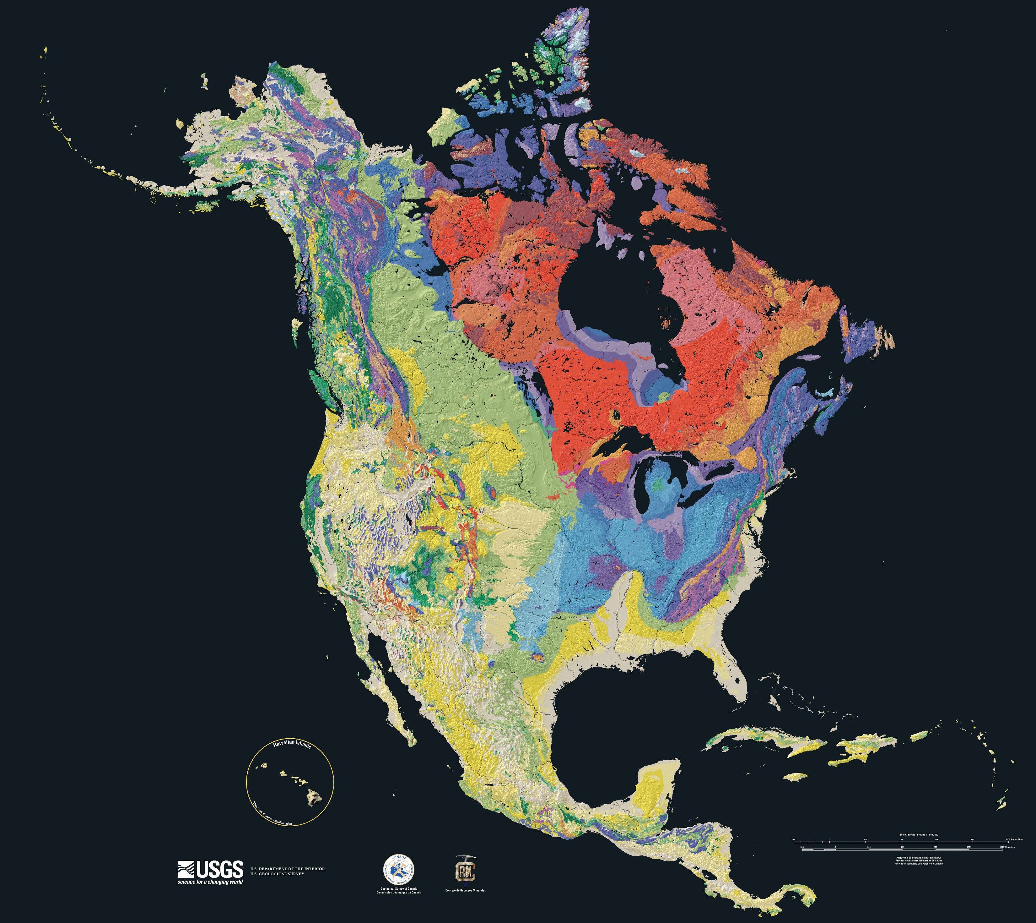
full map and key (Tapestry of Time and Terrain) available here (131 mb download)
pubs.usgs.gov/imap/i2781/
Hudson’s bay does look like a big meteorite crater, doesn’t it?
Are we to view the map on the basis that the different colors represent the various ages of the rocks on the North American plate? That would make sense since the Laurentian shield with that Hudson’s Bay bullseye in it does make up the core of the plate. What’s also weird is looking at the formations running up to the area of the Madrid Fault, all likely new since yellow seems to indicate the youngest formations. What burned a hole in the center of the continent separating the older Appalachian formations from the rocks just to the southwest of St. Louis or was it an embayment so deep that it’s taken hundreds of millions of years to fill in with debris from the old Appalachians and the newer Rockies.
The Appalachians started getting built about 480 million years ago. They are old and so they are eroded with rounded tops and low elevations. 450 million years ago, they used to be like the Rockies and Alps. In the north, much of the rock is Pre-Cambrian igneous and metamorphic rock(Canadian Shield – oldest rocks known) while they become younger and sedimentary in southern NYS and south. The bedrock to the west of them in NYS etc. is a variety of Ordovician limestones, Devonian and Silurian shales etc. that were deposited before the Pangea supercontinent was formed about 300 million years ago. Limestone means deep water, shales are closer to the continent so they get sediment instead of just deep sea calcareous ooze (dead critter shells), and sandstones are very near shore – often big deltas.
Pangea started to break up about 200 million years ago and the rift between the Americas and Europe/Africa became the Atlantic. The Americas pushing west over the Pacific plates is what has formed the new Rocky Mountains and Andes. The subducting plate margin there is the cause of the volcanoes along the west coast and the really big earthquakes that happen frequently there. The interior and east coast earthquakes are more like the creaking and settling of an old house as opposed to the bulldozer hitting the house like on the west coast. Some of the east and northern earthquakes are still due to rebounding from the ice sheets that were pushing the interior part of North America down until 12,000 years ago.
Wegener first proposed the concept of continental drift in 1912. He was largely ignored. The data proving that the continental drift was real was developed by accident in the 1950s and 1960s while mapping was being done for installing trans-ocean cables as well as studying paleo-magnetism. Once some of the researchers realized what was going on, they had to be very careful about how they described their discoveries because if they mentioned continental drift, then their careers were finished. Eventually the weight of evidence was so big that the ridiculous concept had to be accepted as fact. This basically occurred in the 1960s and completely changed the fields of geology as well as impacting biology, especially understanding evolution.
Yeah, we covered much of the continental drift theory in my geophysical fluid mechanics course back in the late 1960s. It was always interesting that the discovery of matching paleomagnetic lines spreading equally east and west from the central Atlantic pretty much proved Wegner’s general ideas about the the American plates drifting away from the Eurasian/African plates. Much of the last forty years has been spent trying to understand just how the Atlantic unzipped. Even better, once plate tectonics was accepted, the geologists could look for the data supporting the formation of Pangaea, which explained the formation of the Appalachians and the different rocks which make up the northeast corner of the US and Canadian maritimes.
You may appreciate this story about the original sonar mapping that established the presence of the Atlantic Ridge with its rift valley.
http://mentalfloss.com/article/60481/how-one-womans-discovery-shook-foundations-geology
Nice picture. What does it mean?
It is a geologic map of north america. The colors are indeed based upon the ages of the rocks, with also a contrast between sedimentary and igneous/metamorphic rocks. For example the oranges/pinks are the Precambrian (notice the exist largely in Canada in the Canadian shield. Then around Hudson bay you have remnants of Paleozoic sediments that are left from the larger deposit of the past (On and Mb parts of the coast). Blues and Purples are Paleozoic, and cover both the Appalachians as well as much of the mid continent. West of these you get to the greens of the Mesozoic and the yellows and the whites of the Cenozoic. One thing that stands out immediately is the vastly different appearance of the Rockies and West compared to things east, due to the relatively recent geologic activity in terms of faulting and volcanism in the west.
Essentially the map reflects the efforts of geologists since the 1820s to understand the geology of north America. In particular their efforts at mapping regions are rolled up on the map.
Needless to say lots of books exist to explain in more detail.
rd @ 10:40 pm
Thank you for your insightful explanation & detail. Most appreciated.
You folks may appreciate John McPhee’s “Annals of the Former World” which is a series of stories (available as separate books) where he crosses the US on I-80 with various local geologists over a period of 20 years. It is a very good lay discussion of US geology and how geology impacted local development.
http://www.amazon.com/Annals-Former-World-John-McPhee/dp/0374518734
Great recommendation! McPhee lays out the geology in a well-written engaging style which does not bore the reader and provides surprising tidbits of information on a regular basis. His books explain the forces which create a continent, including that simmering cauldron up at what we call Yellowstone.