Source: WonkBlog
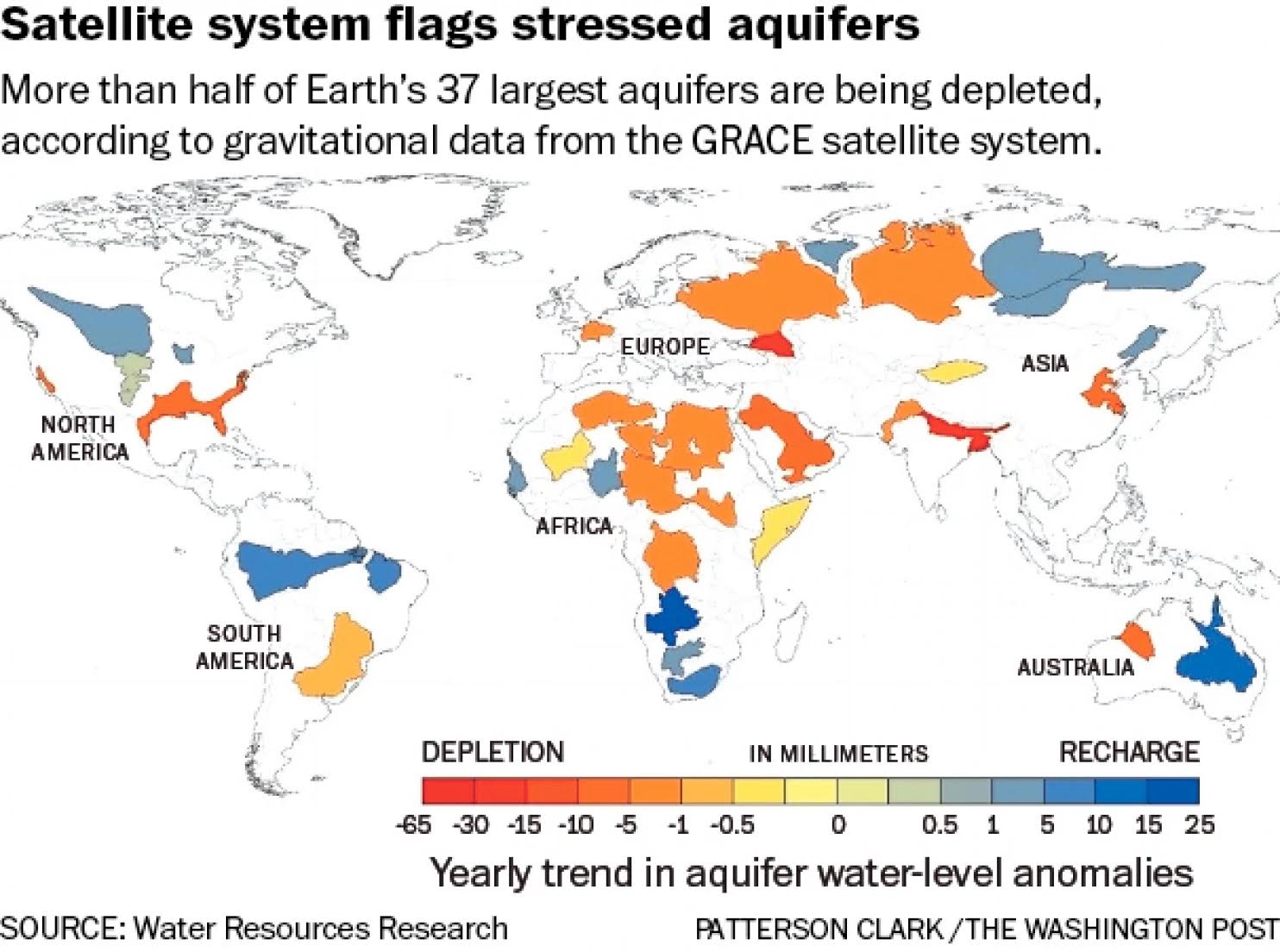
Satellite System Flags Stressed Aquifers
June 24, 2015 7:30pm by Barry Ritholtz
This content, which contains security-related opinions and/or information, is provided for informational purposes only and should not be relied upon in any manner as professional advice, or an endorsement of any practices, products or services. There can be no guarantees or assurances that the views expressed here will be applicable for any particular facts or circumstances, and should not be relied upon in any manner. You should consult your own advisers as to legal, business, tax, and other related matters concerning any investment. The commentary in this “post” (including any related blog, podcasts, videos, and social media) reflects the personal opinions, viewpoints, and analyses of the Ritholtz Wealth Management employees providing such comments, and should not be regarded the views of Ritholtz Wealth Management LLC. or its respective affiliates or as a description of advisory services provided by Ritholtz Wealth Management or performance returns of any Ritholtz Wealth Management Investments client. References to any securities or digital assets, or performance data, are for illustrative purposes only and do not constitute an investment recommendation or offer to provide investment advisory services. Charts and graphs provided within are for informational purposes solely and should not be relied upon when making any investment decision. Past performance is not indicative of future results. The content speaks only as of the date indicated. Any projections, estimates, forecasts, targets, prospects, and/or opinions expressed in these materials are subject to change without notice and may differ or be contrary to opinions expressed by others. The Compound Media, Inc., an affiliate of Ritholtz Wealth Management, receives payment from various entities for advertisements in affiliated podcasts, blogs and emails. Inclusion of such advertisements does not constitute or imply endorsement, sponsorship or recommendation thereof, or any affiliation therewith, by the Content Creator or by Ritholtz Wealth Management or any of its employees. Investments in securities involve the risk of loss. For additional advertisement disclaimers see here: https://www.ritholtzwealth.com/advertising-disclaimers Please see disclosures here: https://ritholtzwealth.com/blog-disclosures/
What's been said:
Discussions found on the web:Posted Under
Previous Post
Is This The Top?Next Post
A Measure of Price Pressures

Well these storms seem to be refilling Texas.
Wow, they can measure the gravitational pull of the water in the ground?
Fabulous!
And good to see the Ogallala aquifer nudge into the positive. Lord knows there’s been enough rain in Colorado so far this summer, everything is so green! (no pun intended, legalization fans)
Agree –
Having grown up there in the Denver area the Ogallala was being depleted pretty quickly especially during the last two drought cycles.
Diversions from the hills into reservoirs has helped me thinks.
DWB though derided has been doing a decent job of keeping up with demand.
Colorado in pretty good shape –
Cali and AZ not so much.
The groundwater we humans have been extracting four our modern usage amassed over tens and hundreds of thousands of years. Thus, these aquifers don’t just “refill” like a barrel or a tanker truck.
Depending on the geological make-up, some nearer the surface can recharge over a period of years. But we’re drilling ever deeper, and we’re not giving sufficient time for water to gradually drain through soil strata to the massive chambers below which formed over millenia.
Look at the articles below to get a sense of how grave the situation is becoming, especially in California’s Central Valley. This is hundreds-mile long flood plain which has recharged an equally huge aquifer underneath, but over the last 75 years, agriculture has begun aggressively draining this “free” natural resource with little regard to long-term consequences.
This has caused subsidence which refers to a reduction of surface elevation resulting from the aquifers underneath shrinking. Think about the amount of underground water it’d take for 1000’s of square miles to drop a hundred feet or more. Now, take the weight of the Earth’s surface soil and it doesn’t take a rocket scientist to grasp how that would compact the soils below, permanently altering the holding capacity of these aquifers and you begin to see the gravity of the situation. And this isn’t even bringing the effect of fracking into the conversation…
USGS: Largest human alteration of the Earth’s surface
San Joaquin Valley, California
http://pubs.usgs.gov/circ/circ1182/pdf/06SanJoaquinValley.pdf
San Joaquin Valley sinking as farmers race to tap aquifer
San Jose Mercury News
http://www.mercurynews.com/drought/ci_25447586/california-drought-san-joaquin-valley-sinking-farmers-race
Even scarier than California’s shrinking reservoirs is its shrinking groundwater supply
PBS News Hour
http://www.pbs.org/newshour/rundown/californias-groundwater-loss-mean-entire-u-s/